Units generated:
ACCU
Purchased by:
Commercial in confidence
Project proponents:
Viridios Capital
Verification doc
ACCU Project and Contract Register

Northern Territory
Active
Units generated:
ACCU
Purchased by:
Commercial in confidence
Project proponents:
Viridios Capital
Verification doc
ACCU Project and Contract Register
Viridios Capital is driven by the urgency of this pivotal moment in climate change and sustainable finance. Carbon markets play a vital role in mobilising the necessary capital for the world to reach Net Zero. With deep expertise in this space, Viridios Capital channels investment into high-quality nature-based solutions: projects that not only reduce emissions but also protect and enhance biodiversity.
Viridios owns and manages Conway’s Station, a 1,400 km2 property in the Roper Region of the NT, bordering Arnhem Land to the North and West. Registered on Conway’s Station is The Waterhouse River Carbon Project, an HIR project with feral animal and grazing management as the eligible management activities.
Viridios Capital works closely with the station management team on the ground to ensure all cattle operations are run smoothly in parallel with carbon project activities. A combination of rotational grazing of cattle and humane feral animal control reduces sapling suppression, supporting the regeneration of native vegetation.
To protect the permanence of the carbon sequestered, Viridios Capital implements a proactive fire management strategy, combining early dry season prescribed burning, firebreak construction, and collaborative operations with Bushfires NT and Indigenous land managers. A tiered fire response workflow ensures timely detection, containment, and regulatory reporting, with a focus on minimising vegetation loss and maintaining FullCAM model integrity for ACCU issuance.
Viridios Capital is making a significant investment in Conway’s property project, particularly in infrastructure such as fencing, communications, watering points, and staff, as well as in the collection of high-quality data for Monitoring, Reporting and Verification (MRV) to ensure robust, science-based evidence of both suppression and regeneration.
In 2024, in line with ongoing efforts to meet the requirements for stratification, Viridios Capital engaged EcOz Environmental Consultants to conduct a detailed field assessment at Conways Station. This assessment aimed to identify and document the primary suppression factors impacting sapling regeneration.
Led by experienced ecologists Laura Zaharie and Erin Barritt, the assessment covered 40 vegetation plots (100 m x 10 m each) across a variety of mapped vegetation types and terrain. The main objective was to evaluate disturbances and suppression mechanisms such as browsing, trampling, wallowing, grazing, and invasive weed presence, which directly influence sapling growth and regeneration. The fieldwork included photographing vegetation, identifying dominant woody plant species exceeding two metres in height, measuring basal area using the Bitterlich sweep method (BAF 0.25), and categorising saplings under two metres for visible damage. Evidence of suppression was systematically documented, providing a clear picture of ecological conditions across Conway’s Station.
Results and Evidence of Damage
The Forrester et al. (2025) paper long-term grazing meta-analytic field synthesis, presents a similar picture, with substantial evidence of heterogeneity in grazing pressure and its ecological effects, particularly in Eucalyptus-dominated ecosystems and areas with higher rainfall. The paper also suggests that heterogeneity can be attributed to proximity to water. These results are consistent with our results on Conway’s Station.
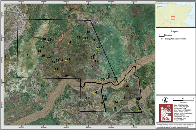
Figure 1: Map showing ecology field assessment sites at Conway’s Station
Successfully identifying eligible project areas in savanna environments is complex and has required investment in detailed, high-quality data collection, including high-resolution satellite imagery, LiDAR, and on-ground ecological assessments, to capture fine-scale variation often missed due to scale, seasonality, and landscape complexity.
The primary goal was to establish with a high degree of certainty which areas were eligible for the project in terms of forest potential and the suppression of sapling growth by cattle and feral animals.
Stratifying the property into eligible and ineligible carbon estimation areas proved challenging, given the savanna’s dynamic nature and the rapid vegetation changes that occur between the wet and dry seasons. This pronounced interseasonal variability makes it difficult to consistently identify and classify eligible areas using satellite imagery alone.
This seasonal variation is addressed by using seasonally consistent satellite imagery, applying an algorithm that calculates annual NDVI averages and variability, and a t-test confirms whether a drop in NDVI is statistically significant, ensuring only meaningful, long-term vegetation loss or suppression is flagged as baseline forest.
Beyond the environmental dynamics, technical mapping challenges further compounded the process. Stratification relies on satellite imagery and field data of differing resolutions. The high-resolution lidar and drone data (at 3–4 cm accuracy) offer very detailed vegetation information, but are limited in spatial and temporal coverage. Conversely, satellite data used across the whole property, while coarser at 0.5-1.5m, was at far higher resolution than the minimum required by the CER. In spite of this, it can still result in small trees and gaps in canopy, leading to under- over-estimation of forest cover. This was mitigated by applying a two-stage model, a supervised classification followed by a linear correction, to reconcile differences and ensure Map Accuracy Assessment (MAA) scores exceed the required 85% threshold.
Lead Contact
Aidan Hall
Corporate Solutions Manager
Address
1-3 Gurrigal Street, Mosman New South Wales 2088, Australia

CSP: ALFA (NT) Limited
Location: Northern Territory
Fire is and has always been the most important tool Aboriginal people in Arnhem Land have used for managing country. Prior to European settlement, the people of Arnhem Land would burn as they traversed their country.

CSP: Corporate Carbon Advisory
Location: Queensland
This project involves strategic and planned burning of savanna areas in the high and low rainfall zones during the early dry season to reduce the risk of late dry season wild fires.
CSP: ALFA (NT) Limited
Location: Northern Territory
Fire is and has always been the most important tool Aboriginal people in Arnhem Land have used for managing country. Prior to European settlement, the people of Arnhem Land would burn as they traversed their country.
CSP: Corporate Carbon Advisory
Location: Queensland
This project involves strategic and planned burning of savanna areas in the high and low rainfall zones during the early dry season to reduce the risk of late dry season wild fires.


